Evaluation of Canada's Extended Continental Shelf Program
February 2019
Table of Contents

List of Acronyms, Abbreviations, and Symbols
- A5
- Arctic Five Ocean Coastal States
- ADM
- Assistant Deputy Minister
- AUV
- Autonomous Underwater Vehicle
- BIO
- Bedford Institute of Oceanography
- CCGS
- Canadian Coast Guard Ship
- CLCS
- Commission on the Limits of the Continental Shelf
- CHS
- Canadian Hydrographic Service
- DFAIT
- Department of Foreign Affairs and International Trade Canada
- DFO
- Fisheries and Oceans Canada
- DG
- Director General
- ECS
- Extended Continental Shelf
- GAC
- Global Affairs Canada
- GSC
- Geological Survey of Canada
- IM/IT
- Information Management and Information Technology
- ISA
- International Seabed Authority
- JLC
- Continental Shelf Division
- NM
- Nautical Miles
- NRCan
- Natural Resources Canada
- O&M
- Operations and Maintenance
- OGD
- Other Government Departments
- UN
- United Nations
- UNCLOS
- United Nations Convention on the Law of the Sea
- U.S.
- United States of America
Executive Summary
As a Party to the United Nations Convention on the Law of the Sea (UNCLOS), Canada is required to file a submission establishing the outer limits of its Extended Continental Shelf (ECS) to the Commission on the Limits of the Continental Shelf (CLCS). International recognition of the outer limits of the ECS solidifies Canada’s sovereign rights over the natural resources of the seabed and subsoil within its ECS. The purpose of Canada’s ECS Program is to map the extent of Canada’s continental shelf beyond 200 nautical miles and prepare, present, and defend the scientific evidence in submissions to the CLCS for the Atlantic and Arctic oceans.
The ECS Program is a horizontal initiative between Global Affairs Canada (GAC), Natural Resources Canada (NRCan), and Fisheries and Oceans Canada (DFO). NRCan, through the Geological Survey of Canada, collects geological and geophysical data to assess the thickness of sediments below the seafloor and provide scientific evidence that Canada’s ECS is a natural component of its continental landmass. DFO, through the Canadian Hydrographic Service, collects bathymetric data to determine the water depth and shape of the seafloor to identify the location of the foot of the continental shelf and 2,500 metre depth contour. GAC, through the Continental Shelf Division, is responsible for the legal aspects of the submission, overall engagement with the CLCS, and diplomatic work including delimitation negotiations with other countries.
The purpose of this evaluation was to determine the Program’s effectiveness, efficiency, and to look forward to the Program’s progress in achieving its ultimate outcome of international recognition of Canada’s outer limits of the ECS in the Arctic and Atlantic oceans.
The timing of this evaluation aligns well with the contributing Departments’ need to prepare for the future phases of the Program, in particular the development of a succession plan to ensure that the necessary expertise is available for responding to the CLCS queries and recommendations when the submissions are reviewed.
Based on key stakeholder interviews, a site visit, and a review of relevant literature and Program operational, performance and financial documents, the evaluation found that the Program is on track to complete and file Canada’s ECS Arctic Ocean submission to the CLCS and defend the Atlantic Ocean submission during a future review by the CLCS. The Program has collected sufficient data to substantiate significant ECS outer limits in the Atlantic and Arctic oceans. When possible, data collection was facilitated by international scientific collaboration, which helped reduce costs and mitigate risks such as remote locations and harsh environmental conditions associated with Arctic research. The evaluation also found that the Program’s governance structure works well and facilitates inter-departmental cooperation.
The evaluation also found that due to the nature of the Program’s activities, expenditures varied annually and by Department, which was mainly a reflection of field operations. However, the data collection methods employed throughout the Program were found to be cost-efficient as alternative methods would not have yielded the same results. The Program has been successful thus far in obtaining the funding required to undertake data collection missions and conduct ongoing work. However, funding is set to end in 2020-2021, while the Program’s timeline is expected to extend well past that date, possibly for the next fifteen years or more.
Lastly, the evaluation found a number of challenges facing the Program, including knowledge transfer and maintaining human resource capacity, as well as information management and technology issues affecting efficiency. Numerous external factors such as long submission review times and delimitation negotiations with countries having overlapping ECS areas with Canada, may impact the Program’s timelines and overall success in achieving its ultimate outcome.
Summary of Recommendations
The following recommendation was derived from the evaluation findings, considerations and conclusions:
It is recommended that, GAC, as the Program lead, in consultation with NRCan and DFO, draft a strategy for the remaining phases of the Program addressing the following areas:
- Remaining activities to be completed with expected timelines
- Human resources and knowledge transfer
- Financial resources
- Data access, maintenance, and storage
Program Background
The United Nations Convention on the Law of the Sea (UNCLOS)
UNCLOS provides that states have sovereign rights over the natural resources of the seabed and subsoil beyond 200 nautical miles (NM) from shore if the continental shelf is a natural prolongation of their land territory. The continental shelf beyond 200 NM is known as the “Extended” Continental Shelf (ECS).
The Convention sets out a process by which coastal states can determine the outer limits of their ECS and gain international recognition for those outer limits. This process involves meeting the scientific and technical requirements of Article 76 of the Convention (collecting and interpreting data, working on the legal aspects of the submission, preparing the submission) and filing a submission with the Commission on the Limits of the Continental Shelf (CLCS).
Where a coastal state intends to make a submission to the CLCS, it must file a partial or full submission within 10 years of becoming a Party to the Convention. On November 7, 2003 Canada ratified UNCLOS and the Convention entered into force one month later.
Canada’s Extended Continental Shelf Program
Canada’s Program to prepare and present its submissions to the CLCS is referred to as “The Extended Continental Shelf Program.” Canada’s submissions involve delineating the ECS in the Atlantic and Arctic oceans. The continental shelf in the Pacific Ocean does not extend beyond 200 NM.
On December 6, 2013, Canada filed a partial submission to the CLCS that supported outer limits encompassing approximately 1.2 million square kilometres (km2) of ECS in the Atlantic Ocean. Also on December 6, 2013, Canada filed preliminary information concerning the outer limits of its ECS in the Arctic Ocean and informed the CLCS there would be a future submission. Canada intends to file its completed Arctic submission early 2019.
Together, both submissions will be the culmination of over 14 years of scientific and technical effort to produce sound, scientifically-justified and defensible evidence toward the eventual recognition of Canada’s submerged landmass and the solidification of the rights to the natural resources on the seafloor and in the subsoil of the ECS in the Arctic and Atlantic oceans.
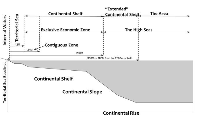
This map illustrates the key elements of Canada’s Extended Continental Shelf.
Text version
Above the surface of the sea:
- Internal Waters
- Territorial Sea from 0 to 12 nautical miles
- Continental Shelf from 12 to 200 nautical miles
- Exclusive Economic Zone from 12 to 200 nautical miles
- Contiguous Zone from 12 to 24 nautical miles
- “Extended” Continental Shelf from 0 to 350 nautical miles, or 100 nautical miles from the 2500 meter isobath
- The High Seas from 350 nautical miles onwards
- The Area
Below the surface of the sea:
- Territorial Sea Baseline
- Continental Shelf that represents shallower sea waters
- Continental Slope where the seafloor begins sloping more sharply downward, and where the depths of the oceans increase rapidly
- Continental Rise represents the final stage in the boundary between the continent and the abyssal plain
Background
Horizontal Initiative
The ECS Program is a horizontal initiative among Global Affairs Canada (GAC), Natural Resources Canada (NRCan), and Fisheries and Oceans Canada (DFO).
The determination of the outer limits of Canada’s Atlantic and Arctic continental shelves relies on two types of seafloor mapping: bathymetry and reflection and refraction seismology. Bathymetry measures the depth of the water and the shape of the seafloor, while seismic reflection and refraction techniques provide high resolution images of the structure of the sedimentary column below the seafloor with which the sediment thickness is determined.
Located at the Bedford Institute of Oceanography (BIO) in Dartmouth, Nova Scotia, NRCan and DFO are responsible for collecting and analyzing data, as well as preparing the submission, adhering to the scientific and technical requirements outlined in Article 76 of UNCLOS. DFO, through the Canadian Hydrographic Service (CHS), collects bathymetric data. NRCan, through the Geological Survey of Canada (GSC), collects geological and geophysical data and has the added responsibilities of undertaking all the operational and logistical planning and arrangements for the surveys, engaging in scientific agreements and collaborations with international partners, and publishing and presenting results to the international scientific community.
GAC, through the Continental Shelf Division (JLC), is responsible for the legal aspects of the submission, overall engagement with the CLCS, and diplomatic work including delimitation negotiations with other countries. Since Canada’s potential shelf is anticipated to overlap with those of other coastal states, Canada will work with neighbouring states to ensure that areas of overlap are not blocked from consideration by the CLCS.
Program Outcomes
Immediate: Successful completion and filing of submissions defining the outer limits of the extended continental shelf to the UN Commission on the Limits of the Continental Shelf (CLCS) based on comprehensive, sound scientific, and technical data.
Intermediate: Positive engagement and favourable recommendations from the CLCS recognizing the outer limits of Canada’s Arctic and Atlantic extended continental shelves.
Ultimate: International recognition of Canada’s outer limits of the extended continental shelf in the Arctic and Atlantic oceans and effective management and development of Canada’s sovereign lands and natural resources.
Program Resources
In Budget 2004, Canada announced $69 million (M) in funding to NRCan ($52.5M) and DFO ($16.5M) to support the scientific work for Canada's submission under UNCLOS to delineate the outer limits of its continental shelf. No funds were allocated to GAC at this time but in-kind services were contributed by GAC to the Program.
In Budget 2008, an additional $40.2M was provided to the Program up to December 2013. The majority of these additional funds were dedicated to NRCan ($19.8M) and DFO ($13.8M), and $6.6M was allocated to GAC to create an expert legal unit to work on the preparation of the submission and to support diplomatic efforts in this regard. Through subsequent budget exercises, the Program received additional funding of $7.9M for the period of 2013-2014 to 2016-2017 for DFO ($4.9M) and NRCan ($3M).
After the decision to file the partial Atlantic Ocean submission with the CLCS in December 2013 and continue gathering data for the Arctic Ocean submission, subsequent funding was sought to continue submission preparation, including two additional Arctic marine survey missions. Funding of $53.6M was approved for the period of 2014-2015 to 2020-2021 for NRCan ($42.4M) and for DFO ($11.2M).
An additional $24.8M for the period of 2016-2017 and 2017-2018 for NRCan ($24.3M) and for DFO ($0.5M) were approved for the addition of a third and final Arctic marine survey that included the use of the Swedish icebreaker Oden.
Subsequent to December 2013, GAC committed to the Government to fund the GAC component of the Program using internally sourced funds. However, there has not been a consistent source of funding provided internally, resulting in a yearly budget deficit in the Legal Branch.
The total amount of funding approved from 2004 to 2015 for the Program is $195,498,972.
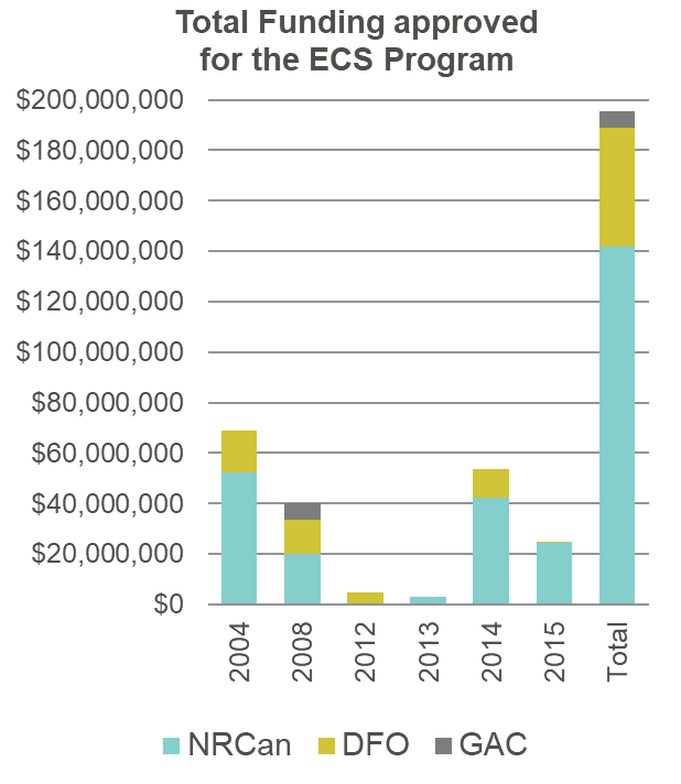
The chart displays the total amount (in millions) of funding approved from 2004 to 2015 for the program.
Text version
The chart displays the total amount (in millions) of funding approved for the program between 2004 and 2015. The turquoise bar represents funding for Natural Resources Canada (NRCan). The yellow bar represents funding for Fisheries and Oceans Canada (DFO), and the grey bar represents funding for Global Affairs Canada.
2004:
- NRCan: $52.5 million
- DFO: $16.5 million
- GAC: $0
2008:
- NRCan: $19.8 million
- DFO: $13.8 million
- GAC: $6.6 million
2012:
- NRCan: $0
- DFO: $4.9 million
- GAC: $0
2013:
- NRCan: $2.9 million
- DFO: $0
- GAC: $0
2014:
- NRCan: $42.4 million
- DFO: $11.2 million
- GAC: $0
2015:
- NRCan: $24.3 million
- DFO: $0.5 million
- GAC: $0
Total:
- NRCan, DFO, and GAC: $195,498,972
Funding for the current phase of the Program is set to end in 2020-2021.
Recommendations from Previous Evaluations
Two previous evaluations of the ECS Program were conducted. The first formative evaluation, completed in 2009, was led by DFO’s Evaluation Division. The second formative evaluation, completed in 2011, was led by GAC’s Evaluation Division.
The evaluations found that the Program was well-designed and demonstrated clear progress toward a completed Canadian submission. The Program's performance however, could be hampered by external factors outside its direct control. These included unstable weather and ice conditions in the Arctic that created challenges for the Program in its data acquisition activities, and the international political environment affecting Canada's relationships with neighbouring States. The Program has employed appropriate mitigation strategies to address these factors.
The external factor having more direct implications for the Program's performance was the heavy workload for the CLCS. Findings indicated that the CLCS had 40+ submissions in its queue for review at the time of the 2011 evaluation. This could cause severe delays when the CLCS considered the Canadian submission unless the CLCS accelerated its then current pace of work. According to the evidence, this delay could extend into decades after the Program files its submissions.
2009 Evaluation
Recommendation 1:
Continued detailed performance-based reporting. The Management Board should prepare an annual performance report and present it to the Federal Advisory Committee for review and the Assistant Deputy Minister (ADM) Steering Committee for approval.
- Management Action:
Performance reports were developed and approved by the ADM Steering Committee for 2009, 2010, 2011, and 2012. The Program did not continue to produce annual performance reports from 2013 onwards, due to planning and conducting data collection surveys in 2014, 2015 and 2016. Since 2015, the Program produces regular reports submitted to management. Program performance is also routinely reported to DGs and ADMs through trilateral meetings and twice a year to the ADM Steering Committee.
Recommendation 2:
Ensure proactive financial and human resources management to prepare for the next phases of the Program. The Management Board should review current resource arrangements and make timely preparations for securing a source of funding starting April 1, 2012.
- Management Action:
In response to this recommendation, the Management Board completed a reprofile request which secured funding through to 2012-2013. Additional Treasury Board submissions were completed in 2012, 2013, 2014, and 2015 which secured funding to 2020-2021.
2011 Evaluation
Recommendation 1:
NRCan, DFO, and DFAIT to develop a plan to address future human resource and financial resource challenges.
- Management Action:
A plan which responded to this recommendation was prepared and approved by the ADM Steering Committee in March 2012. Following the decision to split the submissions in December 2013, thereby extending the Program, the plan had to be revised. An amended human and financial resources plan was therefore developed and approved in June 2016.
Evaluation Scope
The timing of the evaluation aligns well with each Departments’ need to prepare for future phases of the Program. In particular, succession plans to ensure needed expertise is available for responding to the CLCS queries and recommendations when the submission is reviewed in the future.
The scope of this evaluation includes the elapsed period since the completion of the second formative evaluation, between April 2011 and March 2018.
Given the multiple stakeholders involved, this was a horizontal evaluation led by GAC and conducted in collaboration with NRCan and DFO. The evaluation was conducted to meet the requirements of the Treasury Board Policy on Results (2016).
Evaluation Questions
The evaluation was guided by 6 key questions:
Program Effectiveness
- Has the ECS Program realized its intended results/objectives? Has it done so in the most effective manner?
- Have there been any unintended impacts as a result of the Program?
- To what extent does the Program governance structure provide clear and effective direction for timely decision making? Are roles, responsibilities, and accountabilities clearly defined and understood by the three Departments?
Program Efficiency
- Has the ECS Program been delivered cost-effectively? Are human and financial resources sufficient to facilitate required activities and to meet Program objectives?
- What aspects of the ECS Program are working well and are there any areas for improvement?
Looking Forward
- Looking forward, what are the key challenges/barriers that may have an impact on achieving results? What mitigation strategies are in place to address these challenges/barriers?
Methodology
This evaluation drew from multiple lines of evidence and employed both quantitative and qualitative research methods to maximize the reliability of results.
Key stakeholder interviews (n=19)
- Key stakeholder interviews were held with personnel in each of the three Departments involved. The objective of the discussions was to gather in-depth information on program design and delivery, performance measurement, program impacts, and areas for improvement. Key informant discussions complemented other evidence gathered as part of this evaluation, providing qualitative information that clarified data collected with other methodologies.
Document and Literature Review
- A review of documents and files provided the background and contextual information needed to understand how the Program operates. Through the document review, the evaluation was able to determine whether the Program had established clear objectives, the extent to which the Program had implemented intended strategies, and the extent to which the Program is supported by up-to-date agreements, policies and procedures. It further identified the relevant areas of risk and any gaps that might exist.
Review of Operational, Performance and Financial Data
- The collection and analysis of available operational and performance data was a key methodological approach in support of the assessment of the effectiveness and efficiency of program activities. A review of operational data enabled the evaluation to assess the extent to which performance measurement indicators established and collected by the Program support program delivery and efficient decision-making.
- The collection and analysis of available Program budgets and expenditures enabled the evaluation to assess spending across Departments, including identification of cost-efficiencies realized by the Program.
Site Visit
- A site visit to the BIO allowed the team to gather information and data, and identify key considerations leading up to a successful Canadian submission to the Commission on the Limits of the Continental Shelf. The evaluation team also gathered key performance data at the Program outcome level to assess the Program achievements.
- The site visit enabled the evaluation team to address the management of the Program beyond the Canadian submission to the CLCS. The in-person visit also provided regional management and staff with the opportunity to fully contribute to the evaluation.
Limitations and Mitigation Measures
Qualitative analysis provided a comprehensive understanding of the Program’s operating context throughout the various phases from data collection and analysis, to future submission reviews and delimitation processes with neighbouring countries with overlapping entitlements to the ECS. Qualitative methods were mainly used for this evaluation due to the Program having a relatively small number of key personnel. Quantitative data, such as financial records, were also analyzed where available. Each finding was triangulated using a mix of quantitative and qualitative data wherever possible. The recommendations are based on these findings.
Limitations
- Interview participants were current Program personnel, primarily selected on the recommendation of the Program’s Management Board, leading to a potential for bias. Current personnel may also have been reluctant to criticize the Program.
- Mitigation Strategy: The evaluation team informed all interview participants that the purpose of the evaluation was forward-looking to identify barriers in achieving objectives. The participants were therefore encouraged to be candid by evaluators as well as Program management. Given the small number of full-time staff working with the Program, an effort was made by the evaluation team to interview staff from the working-level to senior management at all three Departments.
- Mitigation Strategy: Interview information was triangulated with data collected through document reviews, and through the field visit to reduce a potential for bias and to strengthen findings.
- The evaluation team was reliant on Program personnel in each of the three Departments to provide pertinent documents. Repeated requests for documents and the receipt of draft as well as final versions and multiple copies of documents posed a challenge in terms of data quality and required a significant amount of time to review.
- Mitigation Strategy: The evaluation team followed up with all three Departments multiple times to ensure requested documents including final versions were received. In addition, Program management had an opportunity to review a draft version of the final evaluation report to ensure there were no factual errors.
- A comprehensive assessment of the Program’s cost-efficiency and spending was limited as financial records received from the three different Departments were formatted differently, making it difficult to reconcile spending across the Program.
- Mitigation Strategy: The evaluation team followed up with the three Departments to verify the accuracy of financial data received and inputted the data into a standardized table to facilitate the review of financial information across Departments.
Findings
Finding 1: The Program is on track for completion of Canada’s ECS submissions.
Canada’s deadline for submission of its ECS under UNCLOS was on December 6, 2013. In 2013, the Program was on track to file a full submission for the Atlantic and Arctic Oceans based upon scientific data acquired from 2006-2012.
However, in December 2013, there was a Cabinet decision to split the Atlantic and Arctic submissions. The Program was instructed to expand data collection in the Arctic Ocean, including the North Pole.
The Program filed a partial submission for the Atlantic Ocean in December 2013, meeting its deadline and then proceeded to coordinate three additional surveys in the eastern Arctic Ocean in 2014, 2015, and 2016.
The Program has now acquired robust scientific evidence of Canada’s entitlement to its ECS spanning the entire Arctic Ocean Basin from Amundsen Basin to Canada Basin. The Program is on track to file a scientifically-justified, evidence-based Arctic Ocean submission early 2019.
A presentation of the submission to the CLCS is required as part of the UNCLOS review process. Canada delayed its presentation of the Atlantic Ocean submission for over four years, presenting to the CLCS in New York on February, 6, 2018. This decision was made in hopes that the members of the CLCS at the time of the presentation would be the same members considering the submission. However, due to delays at the CLCS, its composition is likely to change again before Canada’s Atlantic Ocean submission is at the top of the queue to be considered. Canada’s presentation to the CLCS on the Arctic Ocean submission is expected to be made within a year after its 2019 filing.
Program Phases: Canada is currently in Phase 1 for the Arctic Ocean submission and in Phase 2 for the Atlantic Ocean submission.
Phase 1: Submission preparation. The Atlantic Ocean submission was completed and filed with the CLCS. Preparation of the Arctic Ocean submission is in progress.
Phase 2: Maintenance and monitoring of the Atlantic Ocean submission is in progress, and will begin for the Arctic Ocean submission once filed with the CLCS. This phase also includes updating of the official baseline points in Canadian legislation. Timing of the consideration of submissions by the CLCS is unclear as they are experiencing delays due to a large number of submissions in queue. Consideration of the Atlantic Ocean submission may take place in the next five to seven years, whereas the Arctic Ocean submission faces a longer timeline.
Phase 3: Engagement with the CLCS during review as it considers the submissions. This phase is expected to last two to three years each for the Atlantic Ocean and Arctic Ocean submissions, or longer if additional data or revised submissions are required.
Phase 4: Establishment of the outer limits of Canada’s ECS. Receive recommendations adopted by the CLCS on the establishment of the outer limits of the ECS and undertaking necessary domestic regulatory processes to establish coordinates of the outer limits, and file these coordinates with the UN. This phase also includes delimitation negotiations with neighbouring states where is an overlapping ECS. This phase is expected to require at least three years for the Atlantic Ocean submission and another three years for the Arctic Ocean submission. However, it may take longer as delimitation negotiations can be complex.
Finding 2: The ECS Program allowed for successful data acquisition including in uncharted territory such as the Arctic Ocean.
Data collected in the Atlantic Ocean through Canada’s ECS Program supported the 2013 submission, which would add approximately 1.2 million km2 to Canada’s offshore landmass, approximately 1/8th the area of Canada.
The surveys conducted in the Arctic Ocean acquired data that will support a strong scientific case that the ECS is a natural component of Canada’s landmass. Several interview participants felt that while there was sufficient data to support an Arctic submission in 2013, the additional expeditions in 2014, 2015, and 2016 provided more detailed data for the Alpha Ridge and North Pole.
The surveys between 2014 and 2016 included the recovery of important geological samples from Lomonosov Ridge, Alpha Ridge and Nautilus Spur, and also collected highly valuable additional sediment thickness data in Canada Basin on its crustal composition and structure, strengthening Canada’s submission.
Program management confirms that environmental assessments were conducted for all Arctic Ocean surveys to identify potential impacts of the research and mitigate any harmful effects. The environmental assessment completed in 2015 for the eastern Arctic Ocean survey concluded that the survey was unlikely to cause negative environmental impacts as the survey areas were remote, located away from human settlements and marine mammal populations.
A gender-based analysis plus completed for the Program in 2017 by NRCan found no evidence that the Program’s operations or scientific research and analysis adversely impacted gender or diversity.
The success of the data acquisition can be attributed in part to the expertise, dedication and professionalism displayed by Program personnel. A document and literature review highlighted the strong capacity of the Canadian science and technical teams involved in data collection. The survey teams experienced many challenges throughout the missions including, extreme cold weather, heavy ice conditions, and equipment malfunction and breakdown. Lessons learned from earlier expeditions and personnel experiences were vital in saving time, money, finding solutions, and avoiding delays.
Atlantic expeditions
- The Atlantic submission covers approximately 1.2 million km2 of seafloor, spanning 8,000 km from the Labrador Sea, the Grand Banks, and the Scotian Shelf
- 5 Atlantic surveys were completed from 2006-2012:
- 3 surveys by Canada
- 1 joint Canada-U.S.
- 1 joint Canada-Denmark
- Seismic data collected: 11,625 km
- Bathymetric data collected (single channel and multibeam): 273,145 km
Arctic expeditions
- The Arctic submission could cover approximately 1 million km2 of seafloor, spanning the Canada Basin, Alpha Ridge, Lomonosov Ridge, North Pole, and Amundsen Basin
- 15 Arctic surveys were completed from 2006-2016:
- 5 surveys by Canada
- 4 joint Canada-U.S.
- 5 joint Canada-Denmark
- 1 joint Canada-Sweden
- Seismic data collected: 18,906 km
- Bathymetric data collected (multibeam coverage): 117,287 km
- Gravity data collected: 438,973 km
- Rock samples collected: over 800 kg
Program personnel agree that there is confidence that the scientific data will demonstrate the outer limits of Canada’s sovereignty over the seabed and subsoil of the continental shelf beyond 200 NM.
The Canadian Hydrographic Service (CHS) used a number of methods to collect bathymetric data based on weather and ice conditions, resources available, and the type of data needed. Survey lines were charted using ships equipped with hull-mounted deep-water multibeam echosounders, and an autonomous underwater vehicle (AUV), while spot depth measurements were conducted on ice floes and from helicopters.
The Geological Survey of Canada (GSC) collected seismic reflection and refraction data from remote ice camps by drilling holes through the ice to deploy ocean bottom seismometers. The majority of the work involved towing sound sources and receivers behind icebreakers to acquire data. Complementary data sets for potential field analyses include gravity and magnetic studies collected during aerial surveys and the ship-based surveys.
Finally, the Program has been active in producing scientific publications and presentations, including 26 peer-reviewed publications between 2010 and 2015. Scientific interpretation and peer review of data collected through the Program is advantageous as it strengthens the scientific arguments put forward in Canada’s ECS submission through international consensus. Program management has indicated that once the Arctic Ocean submission is filed, the Program will ramp up its efforts to publish more scientific papers reporting results from the work done in the Atlantic and Arctic oceans.
The scientific impacts are immense [for Canada]…there is little presence in the Arctic. The Arctic is the new frontier, and Canada is an important player.
Final Arctic Survey in 2016
The Canada-Sweden joint expedition in 2016, which went from the Amundsen Basin, across the Lomonosov Ridge, Alpha Ridge and into the Canada Basin in a single season, was successful in terms of data and knowledge generation. Program documents revealed that more data was collected overall from different areas than any previous survey. Rock samples and sediment core samples collected by the Canadian team are yielding valuable scientific information that is fundamentally changing our understanding of the formation of the Arctic Ocean. For example, rock samples dredged from the Alpha Ridge included fossilized wood, which suggest that some or all of the Alpha Ridge may have once been above water.
- Ice camps were set up in the Arctic for UNCLOS surveys in 2006, 2008, 2009, and 2010. Ice camps facilitated data collection in remote areas that were inaccessible by ship due to thick ice conditions. Challenges included shifting ice and unpredictable weather.
- Icebreakers were used for UNCLOS surveys in the Arctic in 2007, 2008, 2009, 2010, 2011, 2014, 2015, and 2016. Icebreakers allowed for data collection over thousands of kilometres. The use of two ships at a time (one breaking the ice ahead, while the other followed behind taking measurements) facilitated data collection in extreme heavy ice conditions.
- To access areas in the Arctic unsafe for ice camps or too difficult for icebreakers, Canada pioneered the use of autonomous underwater vehicles (AUVs) to collect bathymetric data along the seafloor. An AUV was deployed once from an ice camp in 2010, and once from an icebreaker in 2011. Both times, the AUV was successful in collecting multibeam bathymetric data and returning to the launch site intact.
- Indigenous marine mammal observers participated on all the Arctic Ocean surveys to ensure geophysical measurements were not fired within 1km of mammals.
Finding 3: The Program has benefitted from international scientific and diplomatic collaboration, which has cascaded into other spheres.
Through the ECS Program, Canada has engaged in international cooperation with several countries in both scientific and diplomatic areas of mutual interest. In general, the relationships fostered through this engagement are positive, and have resulted in mutually beneficial outcomes for Canada and others. Through this collaboration, Canada has been able to learn from other countries’ experiences with their CLCS submissions. As the last state to file its Arctic Ocean submission to the CLCS, Canada can inform its strategies to further strengthen its submission.
Canada has collaborated scientifically with several countries through data collection, analysis, publications, and presentations. These collaborations have been key for Canada to collect the necessary data to support its submission. Joint surveys with Denmark, the U.S., and Sweden were mutually beneficial for cost savings and sharing expertise, as well as for acquiring data. Scientific collaboration is beneficial to establish international consensus on acceptable methodologies for data collection, analyses, and interpretations.
International forums have been key venues for open and transparent dialogue on Arctic issues. For example, Canada participates in collaborative meetings of the Arctic Five (A5), a group of the five coastal Arctic states (Canada, the U.S., Russia, Denmark, and Norway). This group meets annually at A5 Arctic Ocean Workshops to discuss technical and legal issues relating to the delineation of the continental shelf. The most recent Workshop was held in Ottawa in December 2017, where the topics discussed included new scientific data and geological samples, characterization of submarine elevations, and marine scientific research, as well as discussions on climate change impacts and the work of the CLCS. A diplomatic breakout session was also held to discuss legal issues. Interviewees who attended this workshop considered it very successful, and noted the discussions were productive and helpful in determining country positions and finding consensus on scientific and legal matters. The next Workshop will be held in St. Petersburg, Russia in October 2018.
Canada is also a member of the Arctic Council, which is a forum for the discussion of a broad range of Arctic issues, and includes eight Arctic states (the A5 plus Sweden, Finland, Iceland), as well as six pan-Arctic Indigenous organizations. Canada chaired the Council from 2013-2015, and its continued participation in this forum’s discussions and events has provided Canada with increased visibility and a leadership role in Arctic governance and international. There are no equivalent forums in existence for the Atlantic Ocean. However, the players are generally the same as those who attend the Arctic forums, providing a potential opportunity for discussions on Atlantic ECS issues as well.
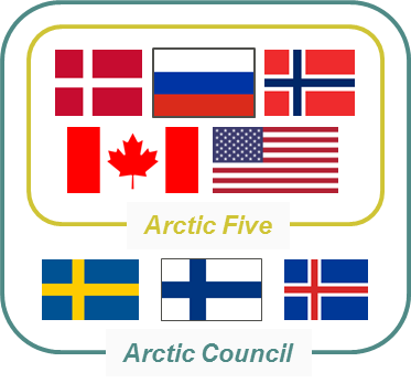
The graphic displays the flags for the countries that are part of the Arctic Five and the Arctic Council.
Text version
The graphic displays the flags for the countries that are part of the Arctic Five and the Arctic Council.
Arctic Five
- Denmark
- Russia
- Norway
- Canada
- United States of America
Arctic Council
- Sweden
- Finland
- Iceland
- Denmark
- Russia
- Norway
- Canada
- United States of America
Ilulissat Declaration
The Ilulissat Declaration was signed on May 28, 2008 in Ilulissat, Greenland by the A5 States, and has been essential to peaceful cooperation in the Arctic. The Declaration commits the States to the peaceful and orderly settlement of sovereignty or boundary disputes, as well as prioritizing and strengthening the protection of the Arctic marine environment, search and rescue capabilities, and transparency in scientific collaboration and cooperation. The Declaration and its priorities were recently reaffirmed by the A5 on its 10th anniversary, on May 22, 2018 in Ilulissat. Although one A5 country, the U.S., has not ratified UNCLOS, their commitment to the Ilulissat Declaration ensures their responsibility to resolve any boundary disputes peacefully and collaborate on the preservation of the Arctic region.
Actively engaging and collaborating with Canada’s neighbours and multilateral partners has been important in the Arctic and Atlantic regions for facilitating peaceful maritime boundary negotiations.
Canada-U.S.
- Canada conducted five joint surveys with the U.S, one in the Atlantic Ocean (2012), and four in the Arctic Ocean (2008, 2009, 2010, 2011). The joint surveys in the Arctic made use of two icebreakers, one Canadian, and one American, working in tandem. This collaborative approach facilitated the collection of much needed Arctic data, while saving millions of dollars for both countries, and also led to the sharing of data and joint publications. This data sharing ensures Canada and the U.S. are on the same page, which will be beneficial for future boundary delimitation negotiations, including the anticipated overlapping areas in the Beaufort Sea and possibly Canada Basin.
Canada-Denmark
- Canada conducted five joint surveys with Denmark, one in the Atlantic Ocean (2009), and an additional four in the Arctic Ocean (2006, 2009). Canadian scientists have also participated in Danish-led surveys off Greenland, while in 2014 and 2016 Danish scientists were invited on a Canadian-led survey facilitating an exchange of data and collaboration on publications. The scientific collaboration also facilitated initial discussions regarding ECS overlaps in the Arctic and Atlantic. In May 2018, Canada and Denmark established a new taskforce to address outstanding issues, including the ECS overlap in the Atlantic Ocean.
Canada-Sweden
- Canada conducted a joint survey with the Swedish icebreaker Oden in 2016. Canadian scientists on the CCGS Louis S. St-Laurent cooperated with the Swedish scientists on the Oden through the exchange of scientific expertise, equipment, data and collaborating on surveying activities. This mutually beneficial expedition also saw the use of innovative data collection techniques on the Alpha Ridge.
Canada-Russia
- Canada has not directly collaborated with Russia on data collection and Russian data remains confidential. However, through international scientific workshops and bilateral discussions, Russian scientists have shared details on their work in the central Arctic Ocean which has been relevant and helpful for Canada’s submission. There may also be future opportunities for an exchange of data and knowledge, and joint publications.
Finding 4: Knowledge transfer and maintaining capacity will pose a future challenge for the Program.
The previous two evaluations conducted in 2009 and 2011, including the audit conducted by NRCan in 2011, found that the Program faces potential human resource challenges and recommended that a plan to address these issues be developed. The Program in turn created a human resources and financial resources plan in 2012 and updated it in 2016.
According to the amended plan, staffing levels at all three Departments are sufficient for the submission preparation phase of the Program. The core Program staff will likely be reduced during the data maintenance and monitoring phase, but will expand again during the third phase where the Program will engage with the CLCS for the review of the submissions. It is difficult for the Program to accurately predict staffing levels needed for the final phase, as this will depend on a number of factors including the recommendations received from the CLCS and the status of the delimitation negotiations with overlapping countries.
Based on Program documents and interviews, knowledge transfer to relevant personnel and maintaining the scientific, technical, and legal capacity to defend the submissions to the CLCS are potential challenges for the Program. These same issues are being faced by all nations filing submissions to the CLCS due to the uncertainty of when submissions will be reviewed.
Retaining or hiring personnel with the scientific and legal expertise for both the Atlantic and Arctic submissions during the CLCS defence process is vital for the Program’s success. However, current Program staff involved in the data collection, analysis, and submission preparation may not be available during the next phases, as these phases could extend past 2030.
The rotational process at GAC, where personnel change positions every few years, can also make it challenging to predict who will be working on the file in the upcoming years. Current legal staff have science backgrounds, which was useful during the submission preparation. While it may be challenging to find legal experts with the relevant scientific background, interviewees believe this will not pose a significant challenge as there are many GAC legal experts in the Oceans Law Division that are capable of providing effective guidance and advice to a future Canadian delegation.
In the past, the Program has contracted scientific expertise, including retired Program personnel, with specialized geophysical knowledge and skills to participate on survey missions. Most recently, the Program invited a retired scientist and former Canadian CLCS member to present the Atlantic submission to the CLCS. Contracting experts as needed has been helpful for the Program thus far. However, this may not be a sustainable solution as there is no certainty that experts will be available during the defence of the submissions. There have already been a number of retirements and more are expected. There is therefore a need to maintain a certain amount of capacity in-house to update the submission data as needed, produce on-going publications based on Canadian data, and devise a plan to transfer knowledge and institutional memory to incoming staff.
As referenced in the gender-based analysis plus conducted by the NRCan for the Program in 2017, the science and technology field, including Arctic surveying, is predominately a male-dominated field. However, the ECS Program has a higher than average ratio of female scientists compared to the private sector and the federal government. In addition, the Program has seen a number of women in senior management positions including NRCan’s current Program Director, previous NRCan Chief Scientists, as well as DFO’s Hydrographer-in-Charge on the Arctic Ocean surveys.
Finding 5: Information management and technology issues experienced by the Program may affect its efficiency and overall success.
Data Access
There is currently no information management and technology (IM/IT) mechanism within the Government of Canada for Departments to work horizontally on an initiative. Until such a system is implemented, Departments must develop their own systems to work inter-departmentally. This may entail emailing documents, mailing hardcopies or electronic files on USB keys, or providing access to Other Government Department (OGD) personnel by creating accounts on their systems.
The ECS Program handles very large sets of raw data, scientific analyses, maps, supporting documentation, as well as maintaining the submissions. These files are often classified as confidential or Protected B, yet they must be shared between the three Departments in preparing Canada’s submissions under UNCLOS.
Working horizontally, the Program does not have access to an official mechanism to share confidential documents. Each Department is on a different network or IM/IT system, where Program staff do not have easy access to data stored on OGD systems. Also, with some Program staff based in Ottawa, including GAC and DFO management, the transfer of files from BIO to Ottawa was noted as challenging by interviewees.
A threat-risk assessment on the Program completed by NRCan in 2012 highlighted the insecure transfer of confidential files between Departments as a potential security risk. Interview participants stated there is no way to work efficiently and effectively with OGDs and with other IM/IT systems, which can negatively affect the Program’s deadlines. Program personnel have found secure workarounds to data access issues. However, these are ad-hoc or temporary solutions that were created at the working-level.
Data Maintenance and Storage
Alongside issues of accessing data, the Program may face challenges to data maintenance and storage in terms of ensuring that the data and related submission documents and maps are maintained and updated over several years, until they are reviewed by the CLCS.
The costs of data maintenance and storage can be as high as $1M per year. The Program however, benefits from cost-efficiencies through NRCan cost-sharing the renewal of software licenses among its geoscience programs. The Program continues to incur the costs to regularly update databases and renew software licenses as required under UNCLOS Article 76. The Program also undertakes regular on- and off-sites back-ups of the data and submissions to ensure they are protected, and monitors data for quality assurance to flag potential data corruption made possible from automatic software updates.
Data Sharing
All country submissions are treated confidentially by the CLCS. Only the coastal state itself can decide to release the submission publicly. The only available information on country submissions is the published executive summaries of the submissions (which are prepared by the state itself), or if the country has an open data policy.
Canada’s data policy stipulates that the data collected through the ECS Program remains confidential until the CLCS provides recommendations on the submissions. There are no current plans to release the full submission itself into the public domain, even after Canada receives successful CLCS recommendations and the outer limits have been adopted into domestic legislation. Other countries may have different data and information sharing policies. For example, the U.S. immediately releases all bathymetric data collected, while Russia does not release any data it has collected. Further, the U.S. has suggested that they may make their entire submission public once it is completed. These data sharing policies can affect scientific collaboration on publications as well as sharing data that can support other country submissions.
Given the collaborative nature of this Program, modifications were made to Canada’s data policy during agreements for joint surveys with Denmark and the U.S., to allow joint release of data for collaborative endeavors. However, to protect Canada’s submission, restrictions were placed on how the data collected during the 2016 Arctic Ocean survey could be used by collaborators. In 2016, NRCan released an open file of JPEG images of seismic reflection data collected between 2007 and 2011. Canada has also submitted the bathymetric data it collected to the International Bathymetric Chart of the Arctic Ocean, which is distributed to users as a 500m gridded product. By providing access to Canadian data, the Program aims to stimulate further scientific interpretation and peer review to strengthen Canada’s submission.
There are no immediate plans for Canada to undertake additional data surveys for the ECS Program, although opportunistic surveys may be looked at on a case by case basis. The submissions will be strengthened through peer-reviewed publications and presentations. The participation of Canadian scientists in international scientific forums is therefore imperative to keep abreast of scientific developments, potentially gain access to new data, and continue to foster collaborative partnerships.
Finding 6: There are numerous external factors that may impact the Program’s success.
Commission on the Limits of the Continental Shelf
The CLCS is comprised of 21 elected members, with elections held every five years. Canada has had two representatives successfully elected to the Commission, one for the 2012 to 2017 term, and one currently serving in the 2017 to 2022 term. Expenses of the CLCS members are paid by their respective countries, however there is a fund established to support members from developing countries, to which Canada has contributed in 2017 and 2018. The ECS Program bears the costs of the elections as well as the Canadian member’s expenses to attend meetings in New York. Having a representative on the CLCS benefits the Program, as the person can provide unique insights to the consideration process as well as help shape a framework that is favourable for Canada’s positive engagement with the CLCS.
Literature and interviews revealed that the CLCS members have varying capacities, and due to the high cost of travel to New York, not all members attend every meeting. The CLCS’ composition is also a factor that can affect the type of recommendations received, as current members could potentially have different views or make recommendations inconsistent with previous practice.
The timeline for the consideration of coastal state submissions is currently quite lengthy. Members meet for a total of 21 weeks per year and produce on average three to four sets of recommendations annually. Following an influx of 35 submissions in 2009 - the first major deadline for countries that ratified UNCLOS prior to 1999 - the length of time taken to review submissions has steadily increased. For countries who filed submissions after 2009, the average time between the submission and receiving recommendations is 5.5 years, compared to much shorter wait times prior to 2009. The CLCS is currently reviewing the 46th submission in queue, which was submitted 9 years prior. The most recent country to receive recommendations in March 2017, had filed their submission in 2009, 8 years prior to receiving recommendations.
There are currently 79 submissions in the queue, of which Canada’s Atlantic submission is number 70. Delays at the CLCS in considering submissions are expected to have varying impacts on Canada’s ECS Program, including on human resources, data maintenance, finances, and the overall Program timeline.
Once Canada’s submissions have been reviewed, the recommendations received could have additional impacts on the Program. The consideration process of the CLCS is confidential and difficult to predict. There is a possibility that the CLCS could request more data, requiring Canada to undertake additional data collection, thereby further extending the Program’s timeline. This was the case with Russia’s submission, where they completed further data collection to file two additional partially reviewed submissions. However, interview participants believe this is unlikely for Canada as the Program has been diligent in producing scientifically robust and defensible submissions. As Canada will be the last to submit among the Arctic nations that have ratified UNCLOS, recommendations to other countries could have an impact Canada’s submission if the recommendations refute Canadian scientific interpretations. Conversely, they could also work to Canada’s advantage.
Strategic Direction
The high-level decision to split the Atlantic and Arctic submissions in 2013 and conduct more mapping in the Arctic Ocean had an impact on the Program’s timelines, overall management, and staff morale.
Splitting the Atlantic and Arctic submissions extended the Program’s timeline by more than five years. Program documents and literature revealed that the Cabinet decision was made at the last-minute and with little consultation with the Program. There was significant staff turn-over in 2014 whereby the Directors from all three Departments and some senior scientists either retired or left the Program. Interview participants described the transition period as difficult due to low staff morale and the amount of work required in a short period to plan and conduct three additional surveys in 2014, 2015, and 2016.
Separate filing dates to the CLCS means that Canada’s Arctic submission will be the last Arctic Ocean submission considered, behind Russia and Denmark. Interview participants explained that Canada’s decision to conduct more research, with the intention of including the North Pole in its Arctic Ocean submission, affected its international credibility somewhat, especially with Denmark. Including the North Pole in Canada’s submission will create an overlap with the Danish and Russian submissions, which also include the North Pole. While ECS overlaps are a normal part of the delineation process, it does create further complexities in relation to the delimitation negotiations in this case because there will be three parties at the table.
Delimitation Negotiations
Once Canada has filed its Arctic Ocean submission, discussions with its neighbours on provisional arrangements in the area of overlap, which could include a provisional boundary line, could begin. However, many coastal states wait until CLCS recommendations are adopted before entering into formal negotiations and most do not finalize boundary lines until this time. While current international relations are co-operative, the political climate in the future cannot be definitively predicted. The Program will soon begin domestic stakeholder consultations with territorial governments and Indigenous groups on the outer limits.
The ECS overlap in the Atlantic Ocean with Denmark is one of the issues the new Canada-Denmark joint taskforce on boundary issues will address and it is possible that provisional arrangements will be in place before CLCS recommendations are available. In relation to the Arctic, some very preliminary discussions with neighbouring countries have taken place, however no formal delimitation negotiations have commenced as Canada has not yet filed its Arctic Ocean submission. The timing of negotiations is therefore unknown, as is their outcome, which may have an impact on the achievement of the Program’s ultimate outcome and success.
Finding 7: The Program’s governance structure works well and facilitates cooperation.
Canada’s ECS Program is a horizontal initiative where GAC, NRCan, and DFO are working together toward a common goal. It is therefore important for the Program to have a governance structure that clearly outlines the responsibilities of the Departments and facilitates decision-making.
At the working level, the multi-disciplinary science teams from GSC and CHS are based at BIO. The evaluation found that the co-location of the teams is beneficial for the Program, allowing for open communication between the Departments, and facilitating the learning and sharing of equipment and techniques. GAC, responsible for legal and diplomatic issues regarding the submission, is located in Ottawa. To mitigate the potential challenges of Program personnel in different locations, the Program holds weekly working-level technical meetings. Interview participants found value in the regular communication to help stay on track during the data analysis and Arctic Ocean submission preparation.
The Program’s Management Board is responsible for the day-to-day delivery of the Program and holds weekly management meetings, which have facilitated interactions among the Departments, solidifying relationships. Some interview participants expressed concern over the dual location of management at BIO and Ottawa leading to management at a distance where some personnel believe their management is not as engaged or “in the loop” compared to previous years. However in general, interviewees agreed that decision-making is effective at the management level, putting the Program on a pathway to achieving its objectives.
The Management Board reports to the ADM Steering Committee which is responsible for the Program’s overall strategic direction and oversight. The Committee plans to meet at least twice a year, however, some interview participants explained that in practice, the Committee has not met as often as planned due to scheduling issues. There has been a significant turnover in ADMs at the three Departments since the beginning of the Program, which has sometimes led to a lack of high-level strategic direction and delayed decision-making at the working level.
The governance structure has evolved since 2004 and no longer includes the Federal Advisory Committee of Director Generals (DGs) to provide advice to the ADM Steering Committee and the Management Board on relevant issues. While this Committee is inactive, there appears to be no negative impact as the DGs from GAC, NRCan and DFO are highly engaged in the Program as needed, often through DG-Director meetings or teleconferences. The DGs often provide strategic direction on an ad-hoc basis when the ADM Steering Committee is unable to convene.
Despite a challenging transition period in 2013 after the split of the Atlantic and Arctic Ocean submissions, the Program managed to work quickly to plan and execute new data collection missions in 2014, 2015, and 2016. This was made possible through the strong informal relationships among Program personnel, leadership, and the collective decision-making by management, which demonstrates an effective governance structure.
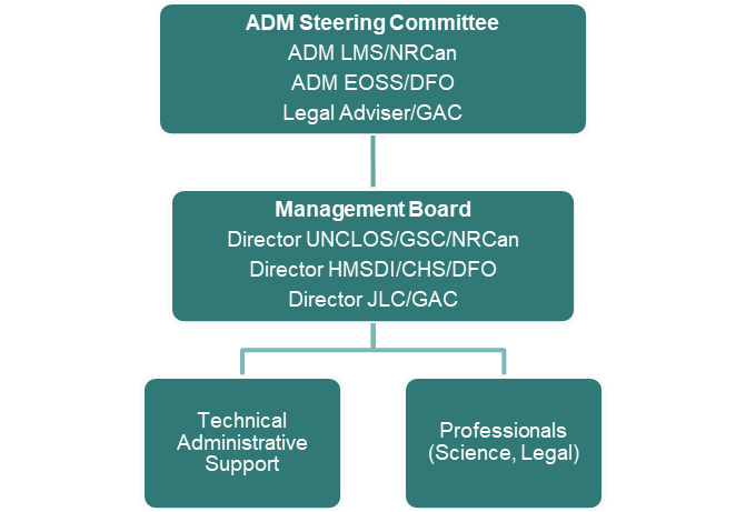
The graphic shows the Program’s governance structure in a hierarchal form.
Text version
The graphic shows the Program’s governance structure in a hierarchal form with ADM Steering Committee on top, followed by Management Board one tier under, and two separate boxes for Technical Administrative Support, and Professionals, aligned in the bottom tier.
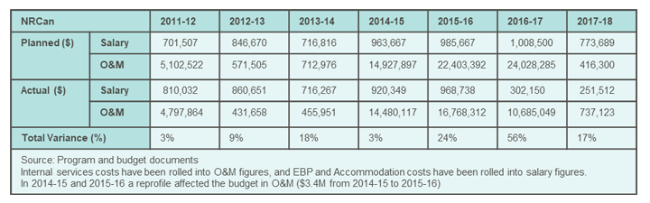
Finding 8: Due to the nature of the Program’s activities, expenditure varies by year and Department, and the Program will experience a budget shortfall after 2020-2021.
Overall, the Program has been successful in obtaining the funding required to undertake data collection missions and conduct ongoing work through several Treasury Board submissions and reprofiling requests. However, funding for the Program is set to end in 2020-2021.
Program management continues to undergo a number of budget exercises to secure funding for all three Departments, to allow for the completion of all phases of the Program. However, the Program has faced some financing issues where two recent reprofile requests by NRCan were denied, leaving Departments to find other avenues to secure immediate funding to complete the Arctic Ocean submission. Program management has stated that the sustainability of the Program is highly dependent on obtaining secured funding.
In some instances, resources have been pooled among Departments to finance ongoing work. For example, NRCan funded GAC in 2016-2017 from unused survey funds as GAC has not received dedicated funding for its work since 2008. The willingness of Departments to share resources highlights the cooperative nature of the Program and the dedication to achieve the common goal of filing the Arctic submission by 2019.
The blue table displays the numbers from Natural Resource Canada (NRCan).
Text version
The blue table displays the numbers from Natural Resource Canada (NRCan).
Planned salary in dollar amounts:
- 2011-12: 701,507
- 2012-13: 846,670
- 2013-14: 716,816
- 2014-15: 963,667
- 2015-16: 985,667
- 2016-17: 1,008,500
- 2017-18: 773,689
Planned operations and maintenance in dollar amounts:
- 2011-12: 5,102,522
- 2012-13: 571,505
- 2013-14: 712,976
- 2014-15: 14,927,897
- 2015-16: 22,403,392
- 2016-17: 24,028,285
- 2017-18: 416,300
Actual salary in dollar amounts:
- 2011-12: 810,032
- 2012-13: 860,651
- 2013-14: 716,267
- 2014-15: 920,349
- 2015-16: 968,738
- 2016-17: 302,150
- 2017-18: 251,512
Actual operations and maintenance in dollar amounts:
- 2011-12: 4,797,864
- 2012-13: 431,658
- 2013-14: 455,951
- 2014-15: 14,480,117
- 2015-16: 16,768,312
- 2016-17: 10,685,049
- 2017-18: 737,123
Total Variance in percentage:
- 2011-12: 3%
- 2012-13: 9%
- 2013-14: 18%
- 2014-15: 3%
- 2015-16: 24%
- 2016-17: 56%
- 2017-18: 17%
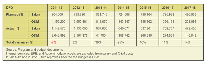
The green table displays the numbers from Fisheries and Oceans Canada (DFO).
Text version
The green table displays the numbers from Fisheries and Oceans Canada (DFO).
Planned salary in dollar amounts:
- 2011-12: 304,000
- 2012-13: 798,330
- 2013-14: 831,746
- 2014-15: 724,506
- 2015-16: 730,164
- 2016-17: 735,993
- 2017-18: 496,059
Planned operations and maintenance in dollar amounts:
- 2011-12: 4,156,200
- 2012-13: 2,552,461
- 2013-14: 812,670
- 2014-15: 343,347
- 2015-16: 345,362
- 2016-17: 366,153
- 2017-18: 228,098
Actual salary in dollar amounts:
- 2011-12: 1,142,575
- 2012-13: 1,135,050
- 2013-14: 967,066
- 2014-15: 640,671
- 2015-16: 637,361
- 2016-17: 708,707
- 2017-18: 478,456
Actual operations and maintenance in dollar amounts:
- 2011-12: 3,646,899
- 2012-13: 2,161,875
- 2013-14: 41,780
- 2014-15: 158,742
- 2015-16: 266,580
- 2016-17: 274,551
- 2017-18: 146
Total Variance in percentage:
- 2011-12: -7%
- 2012-13: 2%
- 2013-14: 39%
- 2014-15: 25%
- 2015-16: 16%
- 2016-17: 11%
- 2017-18: 14%
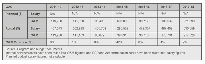
The grey table displays the numbers from Global Affairs Canada (GAC).
Text version
The grey table displays the numbers from Global Affairs Canada (GAC).
Planned salary in dollar amounts:
- 2011-12: n/a
- 2012-13: n/a
- 2013-14: n/a
- 2014-15: n/a
- 2015-16: n/a
- 2016-17: n/a
- 2017-18: n/a
Planned operations and maintenance in dollar amounts:
- 2011-12: 119,288
- 2012-13: 141,958
- 2013-14: 96,495
- 2014-15: 68,688
- 2015-16: 90,717
- 2016-17: 185,532
- 2017-18: 221,698
Actual salary in dollar amounts:
- 2011-12: 467,073
- 2012-13: 562,998
- 2013-14: 405,768
- 2014-15: 280,562
- 2015-16: 472,307
- 2016-17: 467,409
- 2017-18: 530,559
Actual operations and maintenance in dollar amounts:
- 2011-12: 119,288
- 2012-13: 141,109
- 2013-14: 90,672
- 2014-15: 39,891
- 2015-16: 90,716
- 2016-17: 178,761
- 2017-18: 217,029
Operations and maintenance variance in percentage:
- 2011-12: 0%
- 2012-13: 1%
- 2013-14: 6%
- 2014-15: 42%
- 2015-16: 0%
- 2016-17: 4%
- 2017-18: 2%
The two previous evaluations conducted in 2009 and 2011, as well as the audit conducted by NRCan in 2011, found that the Program is cost-effective and efficient. This evaluation examined total Operations and Maintenance (O&M) and salary Program spending from 2011-2012 to 2017-2018, but is unable to clearly determine the Program’s efficiency based on the documents and financial records reviewed. On average, the Program spent 79% of its planned O&M budget, which is much lower than the 2011 evaluation finding of 96.8%. The total variance in spending differs greatly by Department and between years.
Program O&M spending varies from year to year, with data collection years (2012, 2014, 2015, and 2016) incurring higher costs. There are numerous factors that can affect the actual costs of data collection. For example, the smaller size and limited capacity of the Canadian icebreaker CCGS Terry Fox to navigate through the extreme heavy ice conditions experienced in 2014 meant less data were collected and that additional surveying in 2015 and 2016 were required. NRCan’s O&M spending reflects its responsibilities of handling all the costs associated with the survey missions such as planning and coordinating field operations, paying all ship costs, and contracting specialized personnel. NRCan also incurs the costs associated with the production of the submissions and travel costs for presenting the scientific findings of the Program at conferences and meetings.
As noted in the previous evaluations, the data collection methods employed throughout the Program were cost-efficient based on capacity and availability of infrastructure and equipment. Any alternative methods to using icebreakers to collect data during the final three expeditions, such as ice camps or AUVs, would have been unlikely to achieve the same results within the time constraints based on the Arctic data collection season window and Program timelines.
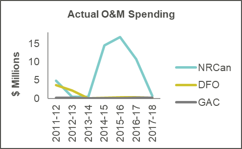
The first graphic shows the actual operations and maintenance (O&M) spending in millions of the three departments from 2011-2012 to 2017-2018.
Text version
The first graphic shows the actual operations and maintenance (O&M) spending in millions of the three departments from 2011-2012 to 2017-2018.
- The blue line displays the numbers from Natural Resource Canada (NRCan).
- 2011-12 (4,8 M)
- 2012-13 (431,658)
- 2013-14 (455,951)
- 2014-15 (14,5 M)
- 2015-16 (16,8 M)
- 2016-17 (10,7 M)
- 2017-18 (737,123)
- The green line displays the numbers from Fisheries and Oceans Canada (DFO).
- 2011-12 (3,6 M)
- 2012-13 (2,2 M)
- 2013-14 (41,780)
- 2014-15 (158,742)
- 2015-16 (266,580)
- 2016-17 (274,551)
- 2017-18 (146,843)
- The grey line displays the numbers from Global Affairs Canada (GAC).
- 2011-12 (119,288)
- 2012-13 (141,109)
- 2013-14 (90,672)
- 2014-15 (39,891)
- 2015-16 (90,716)
- 2016-17 (178,761)
- 2017-18 (217,029)
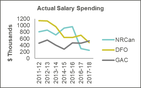
The second graphic shows the actual salary spending in thousands of the three departments from 2011-2012 to 2017-2018.
Text version
The second graphic shows the actual salary spending in thousands of the three departments from 2011-2012 to 2017-2018.
- The blue line displays the numbers from Natural Resource Canada (NRCan).
- 2011-12 (810,032)
- 2012-13 (860,651)
- 2013-14 (716,267)
- 2014-15 (920,349)
- 2015-16 (968,738)
- 2016-17 (302,150)
- 2017-18 (251,512)
- The green line displays the numbers from Fisheries and Oceans Canada (DFO).
- 2011-12 (1,142 M)
- 2012-13 (1,135 M)
- 2013-14 (967,066)
- 2014-15 (640,671)
- 2015-16 (637,361)
- 2016-17 (708,707)
- 2017-18 (478,456)
- The grey line displays the numbers from Global Affairs Canada (GAC).
- 2011-12 (467,073)
- 2012-13 (562,998)
- 2013-14 (405,768)
- 2014-15 (280,562)
- 2015-16 (472,307)
- 2016-17 (467,409)
- 2017-18 (530,559)
Actual salary spending was also higher during the data collection survey years due to overtime costs. NRCan and DFO’s salary spending is expected to remain at current levels over the data monitoring and maintenance phase. However, it will increase again during the review of the submission to ensure there is staff on hand to engage with the CLCS as required. GAC is responsible for funding the Canadian CLCS member at approximately $250,000 per year until 2022, which adds to its increasing salary costs.
The Program was able to reduce the costs of conducting research in the Arctic through collaboration with other countries. Cost efficiencies were realized by chartering the Swedish icebreaker Oden for the 2016 expedition. The Program was approximately $10M under budget due to lower fuel costs and reduced ice conditions, and lower charter costs by Canada that agreed to host a Swedish early career science program onboard the Oden during the survey.
Considerations and Next Steps
Continued Engagement on Article 82
The International Seabed Authority (ISA) was established under UNCLOS to organize and control activities in the Area, which lies beyond the limits of national jurisdiction. Article 82 under UNCLOS requires Parties to make payments or in-kind contributions to the ISA for the exploitation of non-living natural resources within its ECS. For example, if a coastal state finds oil or gas reserves in its ECS and starts production, it must then make annual contributions to the ISA after the sixth year of production. These contributions will eventually be distributed to developing countries that are Parties to UNCLOS on the basis of equitable sharing criteria.
There remains much uncertainty with Article 82 internationally in terms of what constitutes in-kind contributions, what occurs if the coastal state is not profitable through production by its sixth year, and how the contributions or payments will be divided among developing countries. No country has yet made payments to the ISA under Article 82, however Canada may be the first based on oil deposits found in the ECS in the Atlantic Ocean.
Canada does not currently have a domestic framework or mechanism to source Article 82 payments. GAC has begun consulting with Provincial and Territorial governments, as well as with the private sector, which are all implicated in the impending payments. Continued outreach and negotiations between the Government of Canada and stakeholders would be beneficial in establishing a domestic framework, preferably before production begins. In addition, it is important for Canada to retain its presence in the ISA and engage in Article 82 discussions to ensure that the funds are managed well and that the distribution is aligned with the Government of Canada’s international assistance policies.
Leveraging Scientific Research
The ECS Program was able to leverage the surveys to enhance data collection to meet other government obligations and benefit other government programs. For example, the Program was instrumental in acquiring data for Canada’s contribution to the Galway Alliance for ocean mapping of the North Atlantic Ocean. The Program also promoted science outreach through the 2016 Canada-Sweden Polar Expedition where a teacher-at-sea was embedded with the science team to inform the public through social media about federal science and scientists working on Canada’s ECS Program.
Canada can continue to leverage the scientific research undertaken through the ECS Program for other Government-wide initiatives, such as the development of Canada’s new Northern and Arctic Policy Framework. Through the Program, Canada mapped the outer limits of its ECS. However, Canada has not yet mapped the entirety of the Atlantic and Arctic oceans, nor the Pacific Ocean.
As the Arctic Ocean undergoes rapid and unprecedented environmental changes, new navigation and resource extraction opportunities will be presented, requiring further research. Additional seafloor mapping initiatives can create detailed regional surveys and high resolution maps of the seafloor and subsoil to better illustrate the structure of the seafloor, and identify potential natural resources. Bathymetric data collected through the Program has already been used in databases to help determine safe navigation routes. Additional ocean charting can further assist with marine shipping by finding more efficient and low impact navigation corridors, such as through the Northwest Passage.
Funding from the ECS Program provided an added opportunity to not only map uncharted territory, but also to upgrade and purchase equipment which has been used in other research initiatives. It is important for Canada to continue investing in oceanographic research vessels and research icebreakers as well as building capacity of people in the science and technology fields, capable of operating icebreakers and conducting innovative research using new and changing technologies. This could be accomplished by funding innovative marine geoscience programs that would build on Canada’s ECS Program and train the next generation of geologists, geophysicists, hydrographers and oceanographers. As the ECS Program timeline will extend well past 2021, it will be important to have the scientific and technical expertise available to conduct further research to understand all of Canada’s lands, whether onshore or offshore.
Long-term Planning for the Development of Natural Resources in the ECS
Long-term planning is needed in order to achieve the effective management and development of the natural resources in Canada’s ECS. A future coordinated national ocean mapping program and natural resources assessments of Canada’s extensive offshore lands could be a future consideration for Canada.
Currently, the value of the mineral wealth in Canada’s ECS has yet to be determined. Resource assessments could be conducted to help determine the value of resources, and the viability of development, especially in the Arctic Ocean, and to inform delimitation negotiations in areas of ECS overlaps. Canada’s submissions for the Atlantic and the Arctic oceans will add an estimated 2.2 million km2 to its landmass. Canada’s resource potential in its ECS is therefore expected to be significant, having implications for local economic development, as well as Article 82 payments under UNCLOS.
While there are some private companies undertaking oil and gas exploration in the Atlantic Ocean, the economic potential of oil and gas deposits in the Arctic Ocean is largely unknown. There may be frozen methane gas deposits, however the technology to develop the resource does not yet exist. In addition, there are many challenges associated with resource extraction in the Arctic Ocean such as harsh conditions, high expenses, and environmental risks of transporting resources.
Stakeholder engagement regarding potential future natural resource exploitation is needed. This includes engagement with Provinces and Territories, regional governments and leaders, Indigenous communities, environmental groups, and the private sector to discuss mutual economic benefits, employment, cultural implications, and mitigating environmental impacts.
Conclusions
Overall, the Program is well-managed and is on track to achieve its outcomes. Science diplomacy, collaboration, and cooperation are key characteristics that have contributed to the Program’s success thus far. Open and regular communication, as well as co-location of the scientists, aided in forming good working relationships across the three Departments and between the scientists and legal experts. These relationships have enabled staff to overcome many obstacles including the 2013 decision to split the Atlantic and Arctic Ocean submissions, extending the Program’s timeline. Cooperation with external stakeholders has also been important for successful scientific expeditions and maintaining Canada’s positive international relationships. The Program’s governance structure is effectively facilitating the inter-departmental cooperation and open lines of communication. Having the right people at the table together has been key to the Program’s success thus far.
The data collected by the Program’s expeditions, almost entirely in uncharted territory, is a great achievement in itself. The teams had to work in difficult physical conditions during the Arctic Ocean expeditions in particular, proving their professionalism, dedication, capacity, and ability to learn from past experiences, adapt, and apply new, innovative approaches to the challenges faced. Given the relatively small budget of $195M for the size and scope of the Program, the scientific teams were able to collect highly useful new data that will contribute to the CLCS submissions, and possibly add 2.2 million km2 to Canada’s landmass. This data will also have implications beyond the submissions themselves, contributing to broader scientific inquiry, as well as Canada’s leadership in ocean mapping.
Looking forward, several challenges still lie ahead for the Program. Once both submissions are filed with the CLCS, the wait times for the actual review and provision of recommendations remains unknown, and may push the Program’s end date out decades. Maintaining human and financial resources has been a challenge for the Program thus far, and will continue to pose a challenge as the ultimate Program timeline is uncertain. There will also be implications for other sectors beyond the scope of the Program itself that will be important to consider in the coming months and years, such as engagement on Article 82 of UNCLOS, leveraging the Program’s scientific research, and long-term planning for the development of natural resources in the ECS.
Recommendation
It is recommended that, GAC, as the Program lead, in consultation with NRCan and DFO, draft a strategy for the remaining phases of the Program addressing the following areas:
- Remaining activities to be completed with expected timelines
- Human resources and knowledge transfer
- Financial resources
- Data access, maintenance, and storage
The ECS Program developed a human resources and financial resources plan in 2012 and an updated version in 2016 in response to the second formative evaluation. The most recent plan outlines the remaining phases of work along with the main activities to be completed at each phase, the human resources required by Department until phase 3, and a summary of financial resources received thus far with a planned budget to 2020-2021.
A forward looking Strategy should be developed that includes an updated version of the 2016 plan. The Strategy should reflect the activities to be completed after the Arctic Ocean submission is filed with updated expected timelines that acknowledge that the timelines are not concrete and depend on the review times of the CLCS.
The Strategy should include an updated list of human resource requirements by Department to complete the remaining activities including the final Program phase if possible. The Strategy should also include a plan on how the Program aims to address knowledge transfer to relevant personnel to the final phases of the Program.
The Strategy should also include an updated financial resources budget with existing finances to 2020-2021, that estimate the funding required to complete all four phases of the Program, while acknowledging that Program timelines may change due to a number of factors. As it stands, the Program does not have sufficient funding to complete the remaining phases.
Lastly, the Strategy should explore ways to address data access, maintenance, and storage issues identified in this evaluation for the long-term. This could be through the development of an IM/IT plan that includes an official mechanism to share data among Departments, dedicated financing for software and hardware purchases and updates, as well as IM/IT staff requirements.
Management Response and Action Plan (MRAP)
It is recommended that, GAC, as the Program lead, in consultation with NRCan and DFO, draft a strategy for the remaining phases of the Program addressing the following areas: Remaining activities to be completed with expected timelines; Human resources and knowledge transfer; Financial resources; Data access, maintenance, and storage.
| Management Response & Action Plan | Responsibility Centre | Time Frame |
|---|---|---|
Management Response: Agreed: Global Affairs Canada, through the Continental Shelf Division (JLC), will draft the strategy, based on updating and expanding where necessary the existing Human Resources and Financial Resources Plan from 2016. This will be done in consultation with the Geological Survey of Canada and the Canadian Hydrographic Service. Management Action Plan: The draft will be prepared in the Spring of 2019, following approval and filing of the Arctic Ocean submission, and the 2019 budget process. The Program will then be in a position to evaluate resource requirements based on what the budget might provide, as well as timelines going forward once the submission is filed in New York. The draft strategy will include an update of the existing Human Resources and Financial Resources Plan from 2016, which will include the upcoming phases of the Program and estimated timelines for each. Financial resources and required personnel will also be included for each phase. The strategy will add sections on data access and maintenance, and IM/IT software and hardware requirements. JLC will draft the strategy in cooperation with the ECS Program Directors from the Geological Survey of Canada and the Canadian Hydrographic Service. The strategy will be approved by the ADM Steering Committee. It should be completed and approved by August 2019. | AMC - JLC | Spring 2019 - Summer 2019 |
Appendices
Appendix A: ECS Overlap in the Atlantic Ocean
Canada’s Atlantic Ocean submission was filed on December 6, 2013. A presentation to the CLCS was made in February 2018, but a sub-commission has not yet been established. Canada is 70th in queue.

Map of Extended Continental Shelf overlap in the Atlantic Ocean.
Text version
Text: Map of Extended Continental Shelf overlap in the Atlantic Ocean that includes three descriptive text boxes.
Box 1: Canada-Denmark overlap in Labrador Sea.
*Denmark filed a partial submission to CLCS in 2012 for the southern shelf of Greenland. Denmark filed a non-objection note in relation to Canada’s 2013 Atlantic Ocean submission. The area of overlap is expected to be addressed by the new joint taskforce on boundary issues that was established in May 2018.
Box 2: Canada-France dispute regarding the ECS entitlement of France, in respect of Saint-Pierre-et-Miquelon.
*France filed its submission in 2014.
*The CLCS will not review submissions with disputed areas. Canada has objected to the entirety of France’s submission for Saint-Pierre-et-Miquelon, and France has objected to a portion of Canada’s Atlantic submission.
Box 3: Canada-U.S. potential overlap in the Atlantic Ocean.
*U.S. filed a non-objection note in consideration of Canada’s 2013 Atlantic Ocean submission. While the U.S. has not ratified UNCLOS, it is preparing ECS submissions for all of its relevant areas.
Appendix B: ECS Overlap in the Arctic Ocean
Canada’s Arctic Ocean partial submission was filed on December 6, 2013. The full submission is forthcoming - to be filed to the CLCS in early 2019.
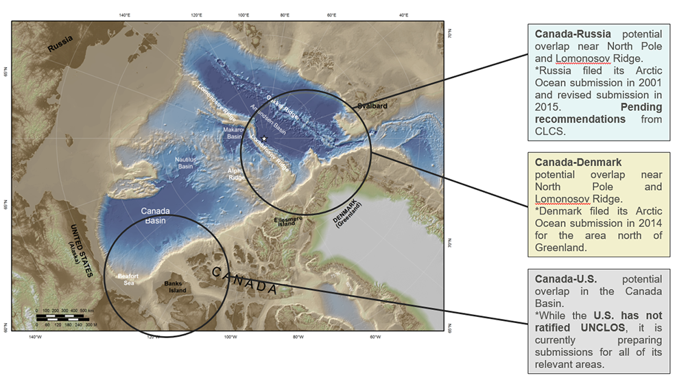
Map of Extended Continental Shelf overlap in the Arctic Ocean
Text version
Text: Map of Extended Continental Shelf overlap in the Arctic Ocean that includes three descriptive text boxes
Box 1: Canada-Russia potential overlap near North Pole and Lomonosov Ridge.
*Russia filed its Arctic Ocean submission in 2001 and revised submission in 2015. Pending recommendations from CLCS.
Box 2: Canada-Denmark potential overlap near North Pole and Lomonosov Ridge.
*Denmark filed its Arctic Ocean submission in 2014 for the area north of Greenland.
Box 3: Canada-U.S. potential overlap in the Canada Basin.
*While the U.S. has not ratified UNCLOS, it is currently preparing submissions for all of its relevant areas.
Appendix C: Theory of Change
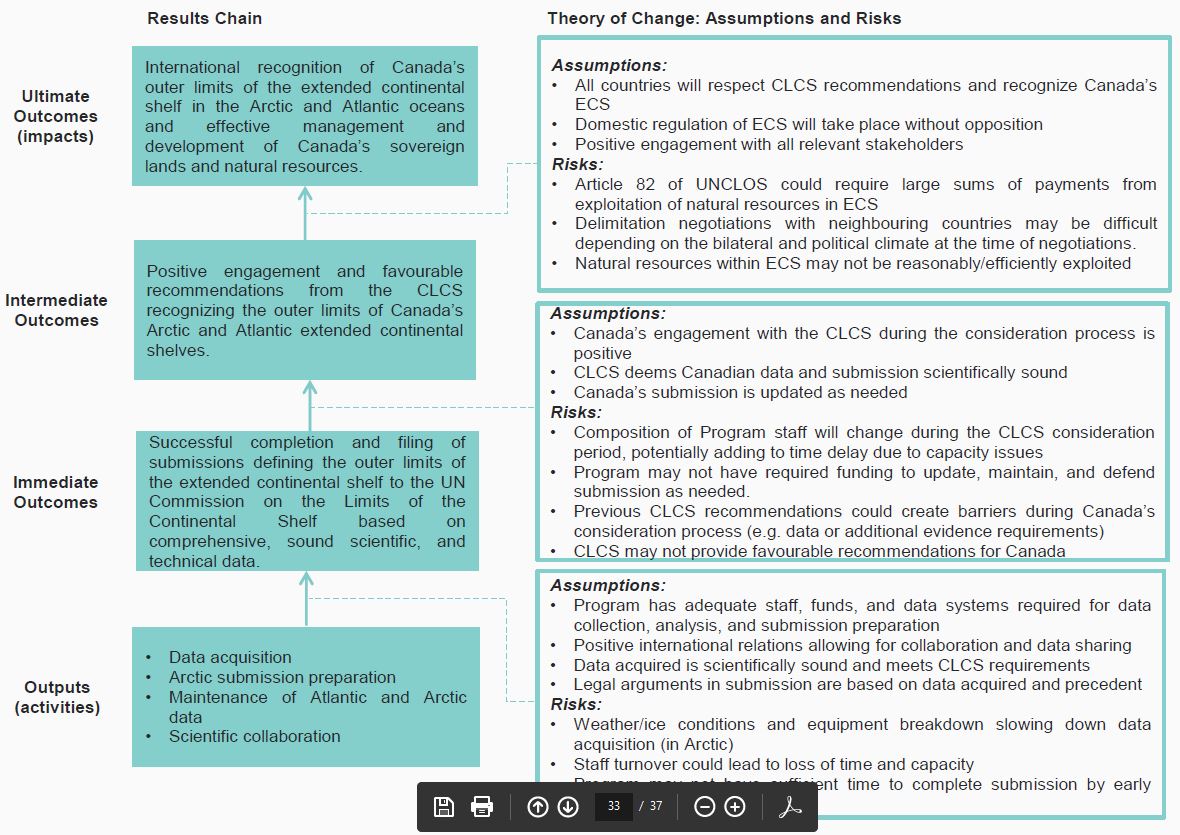
Image of the Results Chain and Theory of Change for Canada’s Extended Continental Shelf Program
Text version
Text: There are four levels in the Results Chain, with arrows leading upwards from each step within the chain, beginning with Outputs (or activities), leading up to immediate outcomes, then to intermediate outcomes, with the final level being Ultimate Outcomes (or impacts). For each level there is descriptive text, and between each level there are associated assumptions and risks that are delineated in descriptive text boxes.
Outputs (activities):
- Data acquisition
- Arctic submission preparation
- Maintenance of Atlantic and Arctic data
- Scientific collaboration
Assumptions:
- Program has adequate staff, funds, and data systems required for data collection, analysis, and submission preparation
- Positive international relations allowing for collaboration and data sharing
- Data acquired is scientifically sound and meets CLCS requirements
- Legal arguments in submission are based on data acquired and precedent
Risks:
- Weather/ice conditions and equipment breakdown slowing down data acquisition (in Arctic)
- Staff turnover could lead to loss of time and capacity
- Program may not have sufficient time to complete submission by early 2019
Immediate Outcomes: Successful completion and filing of submissions defining the outer limits of the extended continental shelf to the UN Commission on the Limits of the Continental Shelf based on comprehensive, sound scientific, and technical data.
Assumptions:
- Canada’s engagement with the CLCS during the consideration process is positive
- CLCS deems Canadian data and submission scientifically sound
- Canada’s submission is updated as needed
Risks:
- Composition of Program staff will change during the CLCS consideration period, potentially adding to time delay due to capacity issues
- Program may not have required funding to update, maintain, and defend submission as needed.
- Previous CLCS recommendations could create barriers during Canada’s consideration process (e.g. data or additional evidence requirements)
- CLCS may not provide favourable recommendations for Canada
Intermediate Outcomes: Positive engagement and favourable recommendations from the CLCS recognizing the outer limits of Canada’s Arctic and Atlantic extended continental shelves.
Assumptions:
- All countries will respect CLCS recommendations and recognize Canada’s ECS
- Domestic regulation of ECS will take place without opposition
- Positive engagement with all relevant stakeholders
Risks:
- Article 82 of UNCLOS could require large sums of payments from exploitation of natural resources in ECS
- Delimitation negotiations with neighbouring countries may be difficult depending on the bilateral and political climate at the time of negotiations.
- Natural resources within ECS may not be reasonably/efficiently exploited
Ultimate Outcomes (impacts): International recognition of Canada’s outer limits of the extended continental shelf in the Arctic and Atlantic oceans and effective management and development of Canada’s sovereign lands and natural resources.
Appendix D: Key Influencing Factors
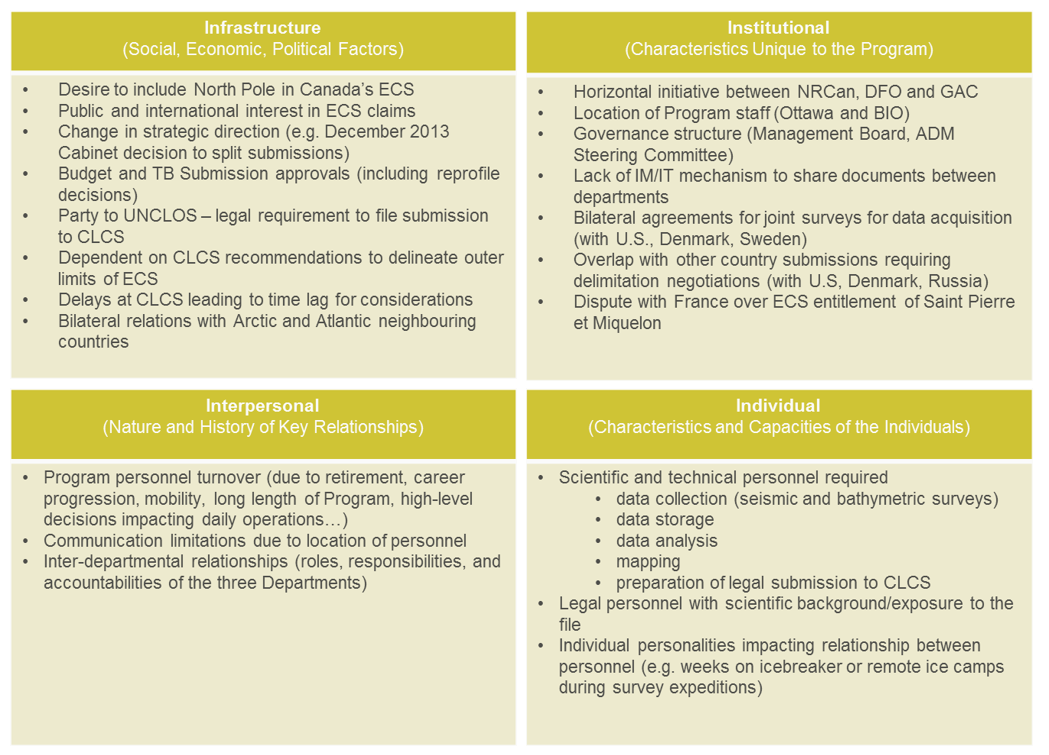
Four areas of key influencing factors
Text version
Text: There are four areas of key influencing factors that pertain to the extended continental shelf program, and the graphic includes four yellow boxes with text that describe the areas and factors in more detail.
Infrastructure (social, economic, and political factors):
- Desire to include North Pole in Canada’s ECS
- Public and international interest in ECS claims
- Change in strategic direction (e.g. December 2013 Cabinet decision to split submissions)
- Budget and TB Submission approvals (including reprofile decisions)
- Party to UNCLOS – legal requirement to file submission to CLCS
- Dependent on CLCS recommendations to delineate outer limits of ECS
- Delays at CLCS leading to time lag for considerations
- Bilateral relations with Arctic and Atlantic neighbouring countries
Institutional (Characteristics unique to the program):
- Horizontal initiative between NRCan, DFO and GAC
- Location of Program staff (Ottawa and BIO)
- Governance structure (Management Board, ADM Steering Committee)
- Lack of IM/IT mechanism to share documents between departments
- Bilateral agreements for joint surveys for data acquisition (with U.S., Denmark, Sweden)
- Overlap with other country submissions requiring delimitation negotiations (with U.S, Denmark, Russia)
- Dispute with France over ECS entitlement of Saint Pierre et Miquelon
Interpersonal (nature and history of key relationships):
- Program personnel turnover (due to retirement, career progression, mobility, long length of Program, high-level decisions impacting daily operations…)
- Communication limitations due to location of personnel
- Inter-departmental relationships (roles, responsibilities, and accountabilities of the three Departments)
Individual (characteristics and capacities of the individuals):
- Scientific and technical personnel required
- data collection (seismic and bathymetric surveys)
- data storage
- data analysis
- mapping
- preparation of legal submission to CLCS
- Legal personnel with scientific background/exposure to the file
- Individual personalities impacting relationship between personnel (e.g. weeks on icebreaker or remote ice camps during survey expeditions)